

Table of Contents
- About the Trail
- Sections of the NPT
- When to Hike the NPT
- How Long Does It Take to Hike the NPT?
- Our Itinerary
- Day 1 – Northville to Woods Lake (12.4 Miles)
- Day 2 – Woods Lake to Mud Lake (18 Miles)
- Day 3 – Mud Lake to Piseco (11.4 Miles)
- Day 4 – Piseco to West Canada Creek (15.9 Miles)
- Day 5 – West Canada Creek to Carry (13.1 Miles)
- Day 6 – Carry to Lake Durant State Campground (13.9 Miles)
- Day 7 – Lake Durant State Campground to Long Lake (14.8 Miles)
- Day 8 – Long Lake to Millers Falls (16.5 Miles)
- Day 9 – Millers Falls to Wanika Falls (13.5 Miles)
- Day 10 – Wanika Falls to Lake Placid (7.7 Miles)
- Leave No Trace
- Additional Items
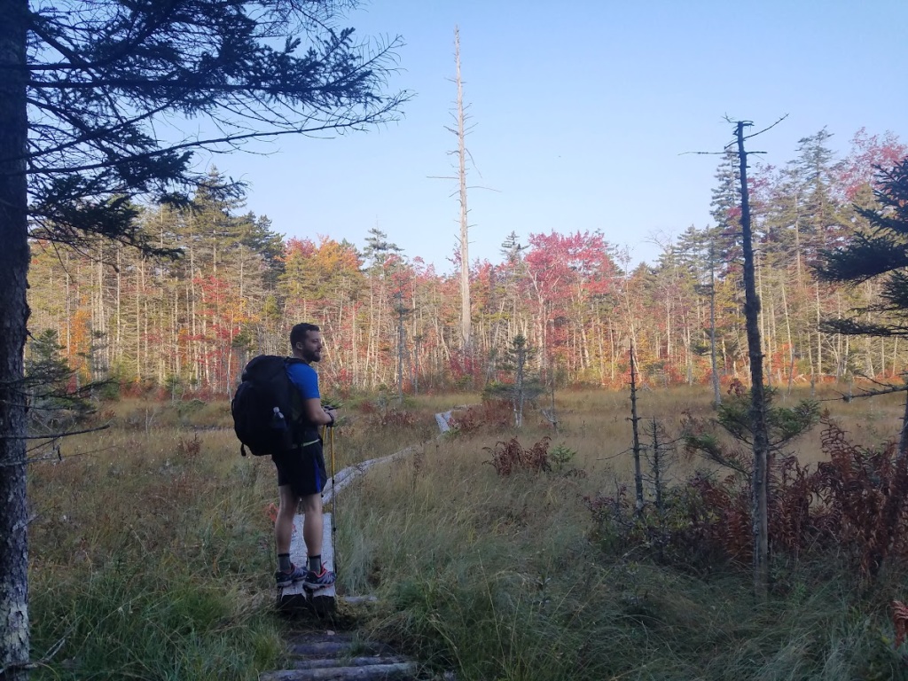
- Extra Pictures
About the Trail
The Northville Placid Trail, or NPT is a 138-mile hike through the heart of the Adirondack Mountains in Upstate New York. It goes through some of the most remote areas in New York, and doesn’t have many crazy elevation changes. Instead, it passes by beautiful lake after beautiful lake.
If your main purpose for backpacking is to simply “get away from it all”, then this is the trail for you. We averaged seeing only about one other group of people per day. This is the perfect amount such that if there’s ever an emergency, you know you’ll see someone, but the other 99.9% of the time, you have the whole place to yourself!
For further reading on the history of this trail, which goes all the way back to 1922, check out the Lake Placid-North Elba Historical Society.

Sections of the NPT

You don’t have to hike this from section to section, and we didn’t either (our itinerary is below). If you send packages to Piseco and Long Lake, the max distance you need to cover is only 57 miles between resupplies, and you can keep your pack nice and light.
The Post Offices are both right in the towns and are not difficult to get to.
Piseco does not have much for resupply, but Long Lake has a small market and camp store, where you can have a near-full resupply if you choose not to mail a package ahead.
When to Hike the NPT

Fall is hands-down the best time to hike in Upstate New York. The foliage colors are world-class, and the cool temperatures make for cozy nights. The bugs are also minimal, or possibly nonexistent.
In my personal opinion, the next best option would be the winter, although if you are not a seasoned winter camper, then this would not be a good place to try it. The lean-tos are fantastic for giving you shelter, but there is a large amount of water crossings that could be hidden by snow and become very dangerous to the inexperienced.
Summer is the next best, and Spring is the worst. The Adirondack Mountains are a very brutal place in the spring thanks to the Black Flies. Unless you enjoy torment, like the people that race during peak black fly season, I highly recommend avoiding May and June for this hike.
One last pro-tip, if you time your visit so that you hit Long Lake on 9/29, stop in into Stewarts for National Coffee Day and grab yourself a nice free hot coffee to warm yourself up!
How Long Does It Take to Hike the NPT?
We hiked the trail in 10 days, but if I were to do it again, I would take it slow, enjoy a full day off in Long Lake, and take the miles a little easier to fully enjoy the scenery.
The miles aren’t difficult to crush on this trail, but due to the sheer remoteness of the trail, it’s worth taking a little easier since it might not be the easiest to get out when you want to if you sustain any sort of injury.
For those reasons, you should plan to take 12 days to hike this trail.

Our Itinerary
We started the hike at the southern terminus which proved to be an excellent choice for three reasons. First, Lake Placid is a much bigger town than Northville, so it felt more rewarding to hike into, there are lots of food options to quench your hiker-hunger, and it’s also a bit easier for transportation out.
Second, hiking from South to North allowed us to get our hiker legs built up for the tallest climb of the trail, which is about 93-miles in. I typically aim to thru-hike this way as it is the best way to avoid injuries that could threaten your whole hike.
Lastly, we hiked in fall, which means beautiful fall foliage. Hiking from South to North felt like a speed run of fall where we got to see the colors change right before our eyes.
Here’s the day to day:
Day 1 – Northville to Woods Lake (12.4 Miles)

It’s very important to start your hike with a celebratory beer. A good 3-miles of the first day is road walking, but it’s not too bad. The views start right away, as you get to walk over the Sacandaga River. It is a little counter intuitive that you park your car at a trailhead and walk through the town instead. I just had to say that so none of you get confused like I was!
I highly recommend the site at Woods Lake. We camped/hammocked here and the views were just fantastic. There are also kayaks stashed around to enjoy the lake. You can jump right in for some swimming too, if it’s not too cold out!
We had a late start and made it to our site at night. However, the view you’ll get to wake up to in the morning is simply exquisite!
Day 2 – Woods Lake to Mud Lake (18 Miles)

The Lean-to at Mud Lake isn’t spectacular, but it’s still always nice to have a lean-to. We didn’t see any mice at this one. The site is next to a water source as well. To be honest, you really don’t need to worry about your next water source much at all on this trail. You will find water within a mile, pretty much anywhere! (But certainly don’t get used to this for other trails.)
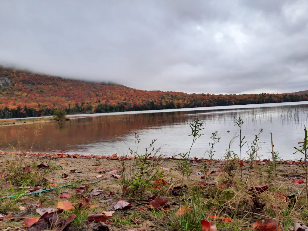
Silver lake is about 12 miles in on this section and you should definitely have your lunch here. This lake was one of my favorite views of the entire hike (it’s the photo in the intro section).
Day 3 – Mud Lake to Piseco (11.4 Miles)
You can resupply at the post office, despite google showing it as closed. If you want to verify however, give them a call. Here is the relevant information to call or mail your package:
PISECO POST OFFICE
402 Old Piseco Rd, Piseco, NY 12139
Phone: 518-548-5668
You have to walk through the town anyway, so it’s a convenient pickup location. The Inn on Piseco Lake offers food, hot showers, rooms, or campsites by the beach. The campsites even have picnic tables, which are a real luxury to simply organize and repack.
There isn’t much in this town for groceries or resupply, so either mail yourself a package or carry enough to get you to Long Lake.
We stayed at a campsite and woke up to a breathtaking view in the morning with the fall colors and the rolling fog.
Day 4 – Piseco to West Canada Creek (15.9 Miles)

I could get used to waking up to this view at Piseco Lake.
The West Canada Creek area is an area rich with history. Keep an eye out for some of the remains that old French Louie left. He was a famous hermit and woodsman that lived in this area. You may also run into a rare sighting of someone hiking the French Louie Loop, which shares a small portion of the NPT here.
All of the lean-tos in this region are fantastic. Many of the lakes have kayaks set aside for recreational usage as well. You really can’t go wrong with a campsite here.

Day 5 – West Canada Creek to Carry (13.1 Miles)
At this point in the trail, your feet are probably going to get wet. That’s if it hasn’t rained on you yet. There’s a number of beaver dams, many that flood, throughout the trail. Unfortunately there’s only so many bridges that can be made.
Embrace the wet feet! Make sure you let them dry at night of course, but take solace in knowing that once your feet are wet, you can trudge on through any flooded crossing without worrying about them getting any more wet!

Day 6 – Carry to Lake Durant State Campground (13.9 Miles)
Remember when I talked about wet feet? Well, it might get even worse. Don’t worry though! At the end of the day you’re going to be staying at the Lake Durant State Campground, where a nice hot shower will be waiting for you!

Day 7 – Lake Durant State Campground to Long Lake (14.8 Miles)
This section passes some beautiful views like Tirrel Pond, however the vast majority of it is in the trees. In the fall, it is a rainbow of color that surrounds your every step.
Early morning will many times yield a thick fog that’s fun to watch envelope the terrain.
You’ll pass the highest climb on the trail today, which makes coming into town at the end of today all the better!
Some of the most memorable parts of a thru-hike are the towns you see along the way. Long Lake is definitely the best place to refresh yourself. So, take a zero or a nero (near-zero) day here if you have the time! We booked a night at the Adirondack Hotel and it had everything we needed from warm beds and hot showers to delicious food.
The resupply point here is the Long Lake Post office. We picked up a box we mailed to ourselves in advance here, but there is a market/camp store that you could resupply from if you wanted. It’s not a full grocery store however, so you might not find everything you want.
LONG LAKE POST OFFICE
1095 DEERLAND RD, LONG LAKE NY 12847
Phone: 518-624-4567

Day 8 – Long Lake to Millers Falls (16.5 Miles)
I hope you are feeling refreshed after the big city, because guess what time it is? That’s right, it’s time to get your feet wet again!

It’s not just getting your feet wet though, you are embracing the beauty of the trail organoleptically, feeling its cool rush to your legs you become one with nature. Or, something like that, it’s hard to think about when you’re pulling your leg out of a foot of MUD!
Anyway, what I’m trying to say is that you just need to take the good with the bad, and the good on this trail certainly outweighs the bad.

Day 9 – Millers Falls to Wanika Falls (13.5 Miles)
This section is filled with beautiful views and some crossings that aren’t too challenging. There’s one wide and low level stream that will either soak your feet, or you can try walking along a fallen log as your bridge. Be sure to perform a risk analysis here, as sometimes its better to just dip your toes in than risk falling.
Near the end of the day you’ll pass Duck Hole, which opens up to an inspiring view of various 46ers in the distance. This view requires you to take just a few steps out of the woods, so make sure you look out for it or you might pass right by!

Day 10 – Wanika Falls to Lake Placid (7.7 Miles)
Nothing too exciting on this portion of the trail, except for the fact that you’re just 7 miles away from FINISHING THE NPT!!!
It’s a two mile walk from where you pop out on Averyville road, into the heart of Lake Placid. The town is familiar with backpackers enough that it isn’t too difficult to hitch in. Either way, you aren’t very far from a nice warm meal!
Our go-to was Wyatt’s for a nice fat burrito.

Leave No Trace
No hiking guide is complete without mentioning to Leave No Trace. Bears are active in this area, although the likelihood of an encounter is pretty rare.
You aren’t required to carry a bear cannister, but you do need to hang your food each night. This isn’t just for bears either, mice and chipmunks have no qualms about digging into your stuff. You really don’t want a mouse to dig a hole into your tent because you forgot a Poptart in your bag.
So, hang your food, don’t litter, and help keep our beautiful earth extricated from litter.

The mice here are fairly bold. One night I set my tent up and a mouse immediately ran to it, jumped on it, and perched herself on the roof. I think she was trying to claim it as her own!
Just remember not to leave food out, and you will be safe.
Additional Items
Be sure to check out my Wilderness Backpacking Checklist as a last-minute check or general gear prep. In addition to what I carry there, make sure you have a map of the area, and if you’d like to be extra prepared, the official ADK Trail Guide. It’s only 5″ by 7″ which makes it convenient to carry with you.
A down jacket along with a rain jacket, pants, a warm hat and lightweight gloves will get you through the September – Mid October weather in Upstate NY with no problem.
Consider joining the NPT Facebook Group for updates and trail assistance should you need it. The people on the page are all incredibly helpful and friendly!
After completing by either end-to-end or section, check out the Schenectady Chapter Adirondack Mountain Club’s instructions for receiving a patch!
Extra Pictures


Have you hiked the NPT? Do you plan to? Let me know in the comments!


Leave a comment